Guest Post: Hello. This is Rosemary, Bonnie's sister, writing in a guest post for Balance and Y-Not!
While Balance and Y-Not were hiking north, I flew east from WA, Mom and Dad drove south from NY, and--aided by the miracle of technology--we all converged on Saturday, April 16, at Fontana Dam NC, to find Balance and Y-Not sitting in the sun waiting for us! What an exciting hiker scene, with some folks hiking across the dam to start their next leg, some hitching into town for supplies, some lolling at the lean-to recovering from the aforementioned partying. We picked up our hikers and headed for a nice little hotel, with showers, good food, and multiple poison ivy remedies (for Balance).
Here is the crew, outside our hotel enjoying the sunshine: Balance, Rosemary, Linda and Stef Seifried, and Y-Not.

Sunday, April 17: The next morning we relaxed with a big breakfast, and packed up our packs for the next leg: Dad and I were to join the thru-hikers for the next 40 miles, the start of the Great Smoky Mountains and some of the toughest hiking so far--and also the first national park. We began at Fontana Dam (1700 feet) and topped out at 6643 feet at Clingman's Dome, the highest point on the AT. This leg finished at Newfound Gap, right in the middle of the national park.


Setting foot on the storied trail--yes, we are on the AT! Altho Balance and Y-Not are almost 200 miles into their trip, this is an exciting moment for Hay Man and I.

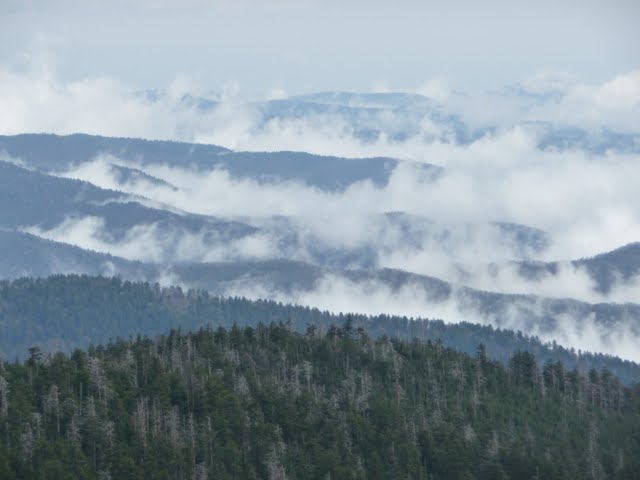
Spring in the valleys, but not up high.

Balance and Sunseeker atop the rickety lookout on Mt. Shuckstack, Great Smokies National Park.

Sitting below the lookout at Mt. Shuckstack, the hikers consult the AT "bible" thru-hiker guide, with mileages, water sources, elevations, and maps of relevant towns that they will re-supply at.


Often the spring beauty is interspersed with yellow trout lilies, as here, or sometimes purple violets or trillium.

We see swallowtail butterflies enjoying the spring beauty, too.


Tuesday, April 19: Day 3 is our toughest day--12 miles of ups and downs (known in hiker parlance as PUDS--pointless up + down). The steepest climb comes right after breakfast, but it is well worthwhile--Thunderhead Mountain, with sweeping views of our entire route to date (see Fontana Dam over Balance's shoulder). We can also see ahead to Clingmans Dome, which we will reach tomorrow. It looks so far away, but by tonight we'll be within 5 miles of it. It is amazing what you can do putting one foot in front of the other, over and over.

Trying to capture the mystic blue ridges of the Smokies.

Sunseeker, Balance, and Y-Not at the summit of Thunderhead, 5527 feet.

Lunch at Derrick Knob shelter, then many more PUDs before our camp.

Our camp on night 3, Silers Bald. Our two tents are on the right, and that is our group having dinner in the sun on the grassy field. The shelter is just to the left, full of more thru-hikers and weekenders.

Wednesday, April 20: Finally our luck turns, and rain and thunderstorms strike us on the next morning. This is what the AT looks like in the rain! That is Hay Man and Sunseeker, skirting the puddle of a trail. Fortunately for us, by midday we plan to meet up with Mom, and head into Cherokee, NC, for a re-supply.

Amazingly, the rain has stopped and we are drying out as we top out at Clingman's Dome. We are close to the road now, and lots of tourists are huffing and puffing up here to take in the views as well (there is a cement tower for all to climb and take in the views). It's chilly in the wind, but we celebrate the views, and the 32 miles we've just hiked. For the thru-hikers, this is the high point of the entire trail: 6643 feet (Mt Washington, NH, which they will reach much, much later, is at 6288 feet). We'll be back here tomorrow to hike the next 8 miles to Newfound Gap.

Meantime, tho, Mom picks us up again and whisks us back down into spring--here we are in the valley, headed for Cherokee, NC, where we'll spend 2 nights while the hikers re-supply, check email, do laundry **very exciting for thru-hikers** and eat out. It is part of the Cherokee Nation, just outside the national park.

Balance and Y-Not taking care of business at the hotel--re-packaging food, measuring out what they'll need for the next leg, drying gear, etc.

Thursday, April 21: We return to Clingman's Dome for our final day of hiking with the thru-hikers. Again, morning mist, but clearing by the time we start hiking.

Water from a rock: Balance refills her water bottle from a spring that ushers forth from a crack in a rock. Water doesn't get any better than that!

Y-Not, Hay Man, and Balance cross a final field of spring beauty, as we drop down toward Newfound Gap.

At last: 40 miles, half of Great Smoky Mountain National Park, and we arrive at Newfound Gap, where the state highway crosses over and hordes of tourists enjoy the vistas. The state border of NC and TN runs thru here as well. Many hikers go into Gatlinburg, TN, to re-supply there--as opposed to Cherokee, on the NC side, where we have been staying. This is the last day for Hay Man and Sunseeker. Tomorrow we'll return here one last time, and Balance and Y-Not will soldier onward.
Friday, April 22: We bid Balance and Y-Not farewell as they head onward: only 1972 miles to go to Maine.

Good luck, Balance and Y-Not! It was an honor joining you for 40 miles of your odyssey. We wish you wings beneath your feet and light hearts as you head northward. We are with you in spirit every day.
This is Sunseeker, signing off the AT.


